27 February 2007

Windows Mobile 6.0

A few days ago (12th February 2007), at the 3GSM trade show in Barcelona, Spain, Microsoft unveiled Windows Mobile® 6, formerly code-named Crossbow, the long-awaited successor to Windows Mobile 5. Windows Mobile 6 improves usability and adds support for Microsoft® Office features previously available only on PCs, and delivers to the small screen a familiar and rich experience that meets the needs of work and life while on the go, all with a single device. In brief, some of the most significant new features include the following:
  • HTML support in email
  • Windows Live for Windows Mobile
  • File transfer capability in Windows Live Messenger
  • New versions of mobile Outlook, Word, Excel, and PowerPoint with rich editing
  • Remote wipe capability for stolen and lost devices
  • Call history in contact cards
  • Tight Vista integration
  • "Calendar ribbon" for more easily viewing schedule by day or week
  • New versions of .NET Compact Framework and SQL Server built-in
However, the first devices using the software aren't expected until spring, however, with the bulk of products using the new operating system likely to come in the second half of the year. In Europe, Orange plans to deliver the SPV E650 smart phone from HTC, and in Japan, SoftBank Mobile Corp. will offer new devices from Toshiba and HTC. And in the United States, the popular T-Mobile Dash will be updated with Windows Mobile 6 and be available in the coming months. Current T-Mobile Dash owners will also be able to upgrade existing devices with Windows Mobile 5.0 to Windows Mobile 6.

Scores of additional mobile operators and device makers from around the globe, including Cingular Wireless, now the new AT&T, Chunghwa Telecom, Dopod International Corp., HP, LG Electronics, Motorola Inc., Palm Inc., Samsung, SingTel, Sprint, Telefónica, Toshiba, Verizon Wireless and Vodafone and Willcom, plan to ship Windows Mobile 6-based devices this year. Many of these partners are expanding large existing portfolios of Windows Mobile powered smartphones.


More information:

http://www.microsoft.com/presspass/press/2007/feb07/02-11WM6SoftwarePR.mspx

http://www.engadget.com/2007/02/07/windows-mobile-6-announced/

21 February 2007

MRGIS

Mixed Reality Geographical Information System (MRGIS) started in City University in January 2005 with the aim of presenting geographical information in a new and educational way. MRGIS is a tangible mixed reality interface designed for windows-based operating systems that allows users to superimpose three-dimensional geographical information into the real environment and interact with it in a user-friendly manner. A screenshot illustrating MRGIS augmenting a three-dimensional map representing City University campus is shown below.

MRGIS provides the necessary technology to visualise 3D geographical information in real-time performance using computers like: desktops, laptops and tabloids. Currently, the multimedia augmentation of virtual information consists of 3D and 2D maps, spatial sound and textual directions. Users can perceive a multimedia augmentation either on monitor-based displays (i.e. CRT, LCD, or TouchScreen) or on head mounted displays (HMDs). Users can interact in a number of different ways including tangible, hardware and software based solutions. Tangible interactions are performed using physical marker cards. Hardware interactions are realised through the use of I/O devices such as the keyboard and the mouse or even more sophisticated devices like magnetic and GPS sensors. Software based interactions are performed using the functionality implemented in the user-friendly graphical user interface (GUI).

06 February 2007

JVRB Article

As part of the LOCUS project, last month, the Journal of Virtual Reality and Broadcasting (JVRB) has published an article I wrote with colleagues from City University, with title ‘Exploring Urban Environments Using Virtual and Augmented Reality’. The paper proposes the use of a specific mobile architecture, for navigation in urban environments. The aim of this work is to assess how virtual and augmented reality interface paradigms can provide enhanced location based services using real-time techniques in the context of these two different technologies.

The virtual reality interface is based on faithful graphical representation of the localities of interest, coupled with sensory information on the location and orientation of the user, while the augmented reality interface uses computer vision techniques to capture patterns from the real environment and overlay additional way-finding information, aligned with real imagery, in real-time. The knowledge obtained from the evaluation of the virtual reality navigational experience has been used to inform the design of the augmented reality interface. Finally, some initial results of the user testing of the experimental system for navigation are presented.

The original article may be accessed online from here.

27 January 2007

Second Life in 3D

Second life is a 3D virtual environment which was entirely built and owned by its residents. Since opening to the public in 2003, it has grown massively and today is populated by a total of 2,954,687 people from around the world. Second Life is a 3D platform that can be used for: presenting, promoting, and selling content to a broad online audience; collaborating and communicating in real time between multiple participants; researching new concepts/products; and training and educating in virtual classrooms. An example screenshot from second life virtual world is shown below.

From the moment a user enters the virtual world, he/she must discover a large digital continent, teeming with people, entertainment, experiences and opportunity. As soon as the virtual world is explored then users must find a perfect parcel of land to build their house or business. It is also possible to be surrounded by the Creations of your fellow residents. Because residents retain the rights to their digital creations, they can buy, sell and trade with other residents. The Marketplace currently supports millions of US dollars in monthly transactions. This commerce is handled with the in-world currency, the Linden dollar, which can be converted to US dollars at several thriving online currency exchanges.


More information:

http://secondlife.com/

http://blog.secondlife.com/

24 January 2007

Mobile Map Interface

Pedestrian navigation and wayfinding for mobile devices is an area of continuous research with increased interest not only from the academic community but also from the rest of the world. In this blog, different approaches have been proposed in the past (i.e. Virtual Navigator, MD3DM VR Interface) but were mainly concerned with virtual reality technology. In parallel to these approaches, a mobile map interface has been developed. The interface is based on 2D visualisation technologies and can display different versions of 2D maps (raster, vector and aerial) and textual information. In addition, it can serve as a basic location-based system (LBS) by providing simple search capabilities (i.e. where is the nearest post office). The main functionality of the interface includes the following three categories: map visualisation, map navigation and finding local information as illustrated below.

The ‘map visualisation’ component provides a simple but effective way of visualising digital maps in mobile devices. To provide a multi-level visualisation framework similar to the ones existing in GIS software, four different types of maps can be displayed. Next, the ‘map navigation’ component allows users to interact with the 2D digital maps by either zooming, rotating or moving in eight directions inside the map using the controls embedded in the interface. Hotspots can be used to enlarge the map to cover the whole mobile display screen. Hotspots can be also used as hyperlinks, linking the map with web-pages that either contains relevant information about the location (i.e. City’s University website) or other types of digital maps such as Google maps. The ‘find local information’ component allows participants to search for geographical information such as street names and services (i.e. list of restaurants, bars, etc) and display information about them on the map.

09 January 2007

First 3D Map of the Universe

An international team of scientists have used Hubble telescope to reconstruct the first ever three-dimensional map at the web-like large-scale distribution of dark matter in the Universe in unprecedented detail. This is one of the most significant achievements in cosmology, which confirms standard theories of structure formation. The 3D map is comparable to visualising a city, its suburbs and surrounding country roads in daylight for the first time. Additionally, major arteries and intersections are exposed and the variety of different neighbourhoods becomes apparent.

The map was reconstructed based on the largest survey of the Universe made by the Hubble Space Telescope, the Cosmic Evolution Survey (COSMOS), carried out by an international team of 70 astronomers. To add 3D distance information, the Hubble observations were combined with spectra from ESO’s VLT (Very Large Telescope) and multicolour images from the Japanese Subaru and Canada-France-Hawaii telescopes. The 3D map, obtained thanks to HST and XMM-Newton data, reveals a loose network of dark matter filaments, gradually collapsing under the relentless pull of gravity, and growing clumpier over time. The three axes of the box correspond to sky position and distance from the Earth increasing from left to right.

More information:

http://www.esa.int/esaCP/SEMZ6GSVYVE_index_0.html

http://hubblesite.org/

31 December 2006

MD3DM VR Interface

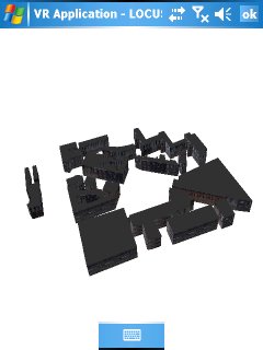
Managed Direct3D Mobile (MD3DM) is a graphics API developed by Microsoft for mobile applications. During the past few months, I have developed another customised mobile 3D graphics engine based on MD3DM and C#. The engine is operational in Pocket PCs, Smartphones, and other devices running Windows CE with the .NET Compact Framework. The graphics engine operates as a separate mode handling the output from the tracking hardware (GPS and/or digital compass) automatically providing six degrees-of-freedom to generate mobile VR applications. An example sceenshot of the MD3DM VR interface representing City University campus is shown below.


Compared to the Virtual Navigator, the advantages of MD3DM is that it takes full advantage of graphics hardware support and enables the development of high-performance three-dimensional rendering. In addition, it provides support to load binary 3D files which are much faster than VRML does. On the other hand, the major disadvantage is that it requires a semi-automatic procedure in order to prepare the binary 3D files that contain multiple textures. Using appropriate functionality of a modelling package (a feature called Render To Texture) the textured model’s coordinates were first flattened and then unwrapped on a new untextured model resulting in having just one texture and one set of UVW coordinates for a whole number of meshes.

10 December 2006

LOCUS in Google Earth

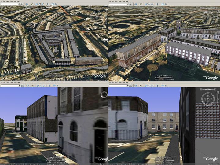
Google Earth is one of the most successful GIS visualisation and interaction applications. The interface provides geo-referenced satellite imagery, which acts as a digital map, and users can perform geo-visualisation and pre-navigation operations. In the LOCUS project, we use the similar geo-referenced imagery to represent the topological information blended with geo-referenced 3D maps in a Virtual reality interface. To provide an alternative virtual reality representation I have imported one of LOCUS geo-referenced 3D maps into Google Earth by converting it from VRML to 3ds format.

The above screenshot illustrates four different views of egocentric and exocentric visualisation in Google Earth. The presented 3D map is very close to City University Campus and it was generated to assist us understand some of the issues involved navigation and wayfinding. The same 3D map will be also used in the user-testing of the VR/Map LOCUS interface. The interface operates on windows mobile 5.0 devices and uses GPS and a digital compass to calculate position and orientation respectively. These data are then used to transform both the geo-referenced digital maps and the 3D maps accordingly and provide the means for user-friendly navigation and wayfinding.

More information about Google Earth:

http://earth.google.com

http://www.gearthblog.com