31 December 2006

MD3DM VR Interface

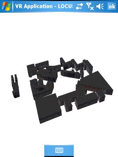
Managed Direct3D Mobile (MD3DM) is a graphics API developed by Microsoft for mobile applications. During the past few months, I have developed another customised mobile 3D graphics engine based on MD3DM and C#. The engine is operational in Pocket PCs, Smartphones, and other devices running Windows CE with the .NET Compact Framework. The graphics engine operates as a separate mode handling the output from the tracking hardware (GPS and/or digital compass) automatically providing six degrees-of-freedom to generate mobile VR applications. An example sceenshot of the MD3DM VR interface representing City University campus is shown below.


Compared to the Virtual Navigator, the advantages of MD3DM is that it takes full advantage of graphics hardware support and enables the development of high-performance three-dimensional rendering. In addition, it provides support to load binary 3D files which are much faster than VRML does. On the other hand, the major disadvantage is that it requires a semi-automatic procedure in order to prepare the binary 3D files that contain multiple textures. Using appropriate functionality of a modelling package (a feature called Render To Texture) the textured model’s coordinates were first flattened and then unwrapped on a new untextured model resulting in having just one texture and one set of UVW coordinates for a whole number of meshes.

10 December 2006

LOCUS in Google Earth

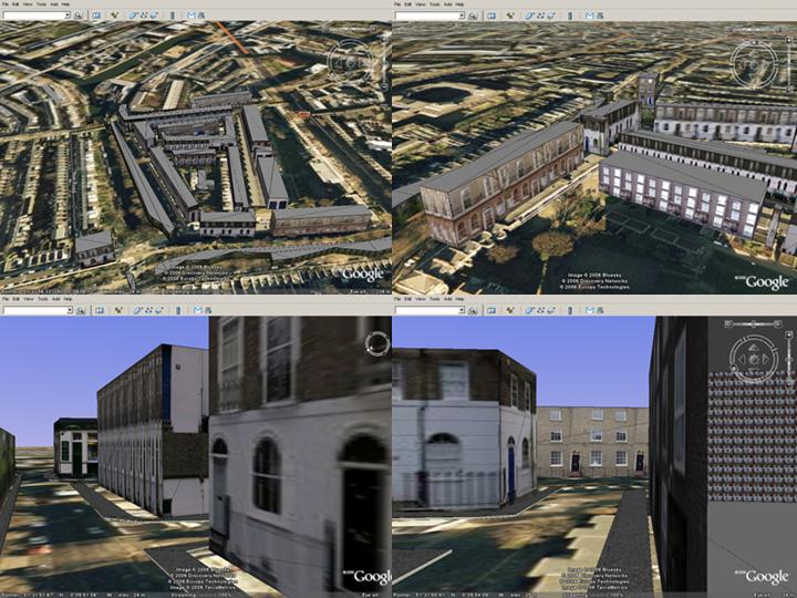
Google Earth is one of the most successful GIS visualisation and interaction applications. The interface provides geo-referenced satellite imagery, which acts as a digital map, and users can perform geo-visualisation and pre-navigation operations. In the LOCUS project, we use the similar geo-referenced imagery to represent the topological information blended with geo-referenced 3D maps in a Virtual reality interface. To provide an alternative virtual reality representation I have imported one of LOCUS geo-referenced 3D maps into Google Earth by converting it from VRML to 3ds format.

The above screenshot illustrates four different views of egocentric and exocentric visualisation in Google Earth. The presented 3D map is very close to City University Campus and it was generated to assist us understand some of the issues involved navigation and wayfinding. The same 3D map will be also used in the user-testing of the VR/Map LOCUS interface. The interface operates on windows mobile 5.0 devices and uses GPS and a digital compass to calculate position and orientation respectively. These data are then used to transform both the geo-referenced digital maps and the 3D maps accordingly and provide the means for user-friendly navigation and wayfinding.

More information about Google Earth:

http://earth.google.com

http://www.gearthblog.com

02 December 2006

VR and AR Gaming

In this month’s issue of the journal of Simulation & Gaming (December 1 2006, Volume 37, No. 4), I have published an article with title 'An exploration from virtual to augmented reality gaming'.

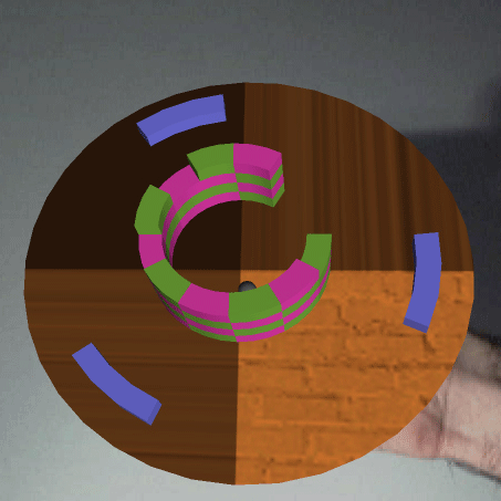
The paper first presents the requirements of modern gaming applications and proposes a classification of the most significant game design issues. Next, to realise the issues related to video and virtual reality gaming, an interactive game engine is designed. As a case study a traditional two-dimensional arcade game, called Breakout, is implemented into a virtual environment.

Collision detection is supported between the graphics components of the application based on Newton laws of physics. To test the effectiveness of our approach, a tangible platform for playing interactive three-dimensional games using video see-through augmented reality techniques is proposed.

The above screenshot illustrates how a user can manipulate the Breakout simulation using his hand in real-time. This allows getting the best viewpoint in a natural and realistic manner. Similarly, the player can move the AR Breakout closer to the camera (and vice-versa) to zoom into the game.

Moreover, a pilot study evaluated six important issues of each application including: efficiency; usefulness; realism; learning; interaction and camera movement. Initial results illustrated that players preferred the VR Breakout in terms of efficiency and the AR Breakout in terms of game play and ease of interactions. Overall, the AR version seems to have all the necessary potentials to become an alternative platform for future gaming applications.

For more information, a draft version of the article can be downloaded from here.

30 November 2006

Virtual Navigator

As part of the LOCUS project, I have developed a mobile navigation system for personal digital assistants (PDAs) based on virtual reality technology. The system is called Virtual Navigator and allows for intuitive pedestrian navigation into urban as well as rural environments. Navigation can be performed in two different modes, including automatic and manual. In the automatic mode, an external GPS device provides position information to the application while orientation is calculated from the GPS heading. In the manual mode, user input is required using the stylus of the device, the keyboard or the graphical user interface (GUI) menu. An example screenshot illustrating how virtual navigation inside City University’s campus (London, UK) is performed is shown below:

As far as the software infrastructure is concerned, Virtual Navigator is designed and implemented for PDAs that make use of the Windows Mobile 5.0 operating system. The graphics functionality is based on VRML technology as it provides the basis for creating mobile and interactive applications. To assist the navigation process, 3D geo-referenced maps are linked with other multimedia content such as 3D text and 3D sound. In addition, the availability of GPRS in the device allows interactive hyperlinks inside the 3D map that provide external navigation information (i.e. link to Google maps). Finally, the GUI is implemented in Microsoft Foundation Classes (MFC) offering the traditional way of windows-based interfaces.

17 November 2006

The LOCUS Project in FT

Financial Times have published today an article with title "Mobile telephones offer a new sense of direction". The article provides an insight of the potential use of GPS mobile phones as well as innovative navigational applications such as the LOCUS project, developed at City University by a team of researchers including myself, Dr. David Mountain, Dr. Vesna Brujic-Okretic and Professor Jonathan Raper. The original article can be found below:

Title: Mobile telephones offer a new sense of direction
Date: November 17 2006
URL: http://www.ft.com/cms/s/78d609ce-74d2-11db-bc76-0000779e2340.html

Global Positioning System (GPS) phones, which pinpoint a user’s exact location, are the poor relation of the mobile convergence market. While camera phones and internet-enabled devices are increasingly commonplace, the brief flurry of excitement about GPS two or three years ago has died down. The signs are, however, that GPS is in for a resurgence. So what’s been holding it back, and what does the future hold in store for the GPS phone?

GPS, originally developed by the US military and made available for civilian use in the late 1990s, is a network of 28 satellites that broadcast time signals by radio. By comparing the signals from three or four satellites, a GPS receiver can determine its exact position. Until now, the main market for the technology has been businesses, principally in the area of fleet management and, to a lesser extent, in security applications.

While consumer phones with in-built GPS functionality are widely available in Japan, they are still rare in Europe. Three main factors have kept GPS phones out of the shops, says Mike Short, vice-president of research and development at service provider O2 and chairman of the Mobile Data Association (MDA): first, the high cost of designing built-in GPS functionality; second, phone companies have been prioritising other functionality made possible by the introduction of 3G networks, such as video; and third, GPS has had a problem with slow “time-to-fix”, meaning that it can sometimes take a long time for a GPS phone to pinpoint its precise location because tall buildings can block the satellite signal. When Galileo, Europe’s answer to GPS, is launched in 2010, this problem is likely to be reduced because it will double the number of satellites.

In the next two years, we can expect to see the GPS market take off. This quarter also sees the launch, in Europe, of a built-in GPS phone, the Twig Discovery, from Benefon, while Nokia has plans to launch a GPS phone next year. Sony Ericsson, meanwhile, has partnered with GPS provider TomTom, a leader in personal navigation devices. By connecting a wireless receiver to the mobile device, users will be able to access TomTom’s GPS service.

To make GPS a success, manufacturers, application developers and network operators need to work together, says Jonathan Raper, professor of geographic information science at City University: “Location technologies have a very long value chain, right through from satellites to maps on devices and a lot of steps in between.” Prof Raper is a member of the steering committee of Location and Timing Knowledge Transfer Network (LTKTN), a consortium set up by the UK’s Department of Trade and Industry (DTI) that has, he says, been valuable in bringing together UK businesses and academics to research and develop GPS solutions.
What applications can the consumer expect to see on GPS phones? There is no single answer, says Prof Raper: “Whereas the initial attempts to produce applications in this area were rather disappointing, it’s because the mobile operators were looking for a single killer application. But I think, in location, the answer is not one killer application, the answer is 3,000 niche applications.”

Most applications fall into one of two categories: enabling users to work out where they are; or allowing others to locate the user, such as applications to enable parents to keep track of their children, or emergency services to pinpoint the location of an accident.

Benefon’s Twig Discovery will include a voice-based satellite navigation system and two location-based services: Twig Finder, which will enable users to track family and friends who also use the device, with their permission; and Twig Alert, which will enable users to send their exact location to a preset contact list of mobile phone numbers or e-mail addresses at the push of a button – the idea being that in the case of an emergency, one of those contacts will be able to respond.

One likely development in the area of navigation applications, suggests Tunc Yorulmaz, a senior executive in the communications and high-tech practice at Accenture, is the convergence of in-car satellite navigation systems with GPS phones. Drivers will use the device to receive traffic information, and then take it with them when they leave the car to use as a phone and a personal navigation device.

Prof Raper is also looking at the benefits of navigation, and points to the economic cost that arises when people get lost. Among the innovative applications being developed by his team is Locus, a navigation tool that will combine GPS functionality and a digital compass with augmented reality software that mixes virtual information, such as a map, with real-life information about the surrounding environment detected through a camera. The screen displays a 2D or 3D image of the user in their environment, and shows them how to get to their desired destination.

If O2’s Mr Short is right, we can expect to see widespread adoption of GPS phones by 2010. Prof Raper believes the social impact of GPS could be comparable with the introduction of the railways or the telegraph system in the 19th century. “Nobody could quite envisage the transformation of society that would result from these changes,” he says. “We are on the threshold of something quite big.”

For more information about the LOCUS project visit:

http://www.locus.org.uk/
13 November 2006

Blender 3D

Something that’s new for me is that I’ve been having a look at Blender recently. After 8 years of being a 3DS Max user I’m quite impressed by how much blender has grown since I last looked at it, and how much more useful than 3DS Max/Maya it could be in computer graphics education. My opinion is due to the fact that it applies graphics principals in a similar manner to the way we teach graphics rather than as fancily named features with a few buttons that make stuff happen. I also like the fact that the built in game engine, compositor and nle video editor provide support for the types of CG education that are about to become more common in universities. I haven’t had a chance to play with the Verses support for networked collaborative scene creation or the Dr Queue render farm possibilities but they look cool. I’m not sure I’d want to use blender in a production environment (yet) because I’d be slower with it, and another drawback is that finding current tutorials and documentation is tricky. I’ve only been playing with the app for a few months on odd evenings when I need a break from writing up my work but I’m impressed enough to be actively seeking someone who would pay me to spend a few months working full time with it to produce some training resources.

11 November 2006

Location-based services for all

The LBS4all (Location-based services for all) project focuses on providing location-based services for people with mobility problems. In particular, it aims in providing navigational help for three types of users including: older, visually impaired and blind people. LBS4all is designed to exploit new mobile computing, positioning and communication technologies in order to aid navigation around urban environments.

The above screenshot illustrates how a user can navigate using the lbs4all software installed on a windows mobile 5.0 PDA. A digital compass is also used (which is inside the rectangular box) to provide orientation information to the user by updating the position on the digital map.

More information:

http://lbs4all.soi.city.ac.uk/

08 November 2006

Virtual Earth 3D

Virtual Earth is a service offered by MSN that provides maps, directions and satellite images and aims in competing Goggle Earth. Virtual Earth supports easy panning and zooming; integrated aerial imagery with labels and street overlays.

However, the greatest difference between Google Earth and Virtual Earth is that the latter introduces 3D maps in a version called Virtual Earth 3D. Specifically, Virtual Earth 3D allows to browse the Earth in 3D including textured buildings for several major cities. Also note that in order to use it, first need to install Virtual Earth 3D (Beta).

More information:

http://local.live.com/