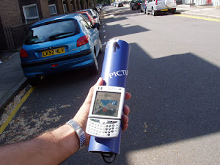
The official testing of LOCUS project has started last week and it is taking place at a residential area near City University campus. Position and orientation information is acquired by the LOCUS system and used to indicate to the pedestrian where is located inside a digital 2D map or a virtual 3D map. The main objective of the study is to test responses of pedestrians when performing navigation and wayfinding operations in urban environments using a personal digital assistant (PDA) equipped with a GPS and a digital compass. The GPS is embedded inside the device while the digital compass is located inside a blue tube as shown below.

In the above screenshot a user is performing a wayfinding task using the VR 3D map. A red line, which is overlaid on user-demand through the client-server architecture, represents the virtual route that the pedestrian has to follow in order to navigate from one position to another and thus complete the task. In a similar way, a red line is superimposed in the digital map. In addition, the digital compass is used as a pointing device allowing pedestrians to alter their orientation in an intuitive manner. As soon as the navigation and tests are finished, then the cognitive workload and the feeling of presence will be qualitatively and quantitatively measured.
Relevant posts:
http://fotisliarokapis.blogspot.com/2007/04/intuitive-pedestrian-virtual-navigation.html
http://fotisliarokapis.blogspot.com/2007/03/lon-lis-seminar.html
http://fotisliarokapis.blogspot.com/2007/02/jvrb-article.html
http://fotisliarokapis.blogspot.com/2006/12/locus-in-google-earth.html
http://fotisliarokapis.blogspot.com/2006/11/virtual-navigator.html
http://fotisliarokapis.blogspot.com/2006/11/locus-project-in-ft.html